


Watch this video to learn how a weather forecast is made! Click here to download this video (1920x1080, 140 MB, video/mp4).
Download a poster version of this video!
Click the above image to download.
Video transcript
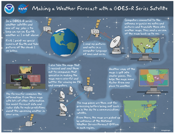
Whoa! Things are looking pretty bad down there, but don't worry. I'm going to give weather forecasters a heads up and help you stay safe. I'm a GOES-R series weather satellite, and one of my jobs is to keep an eye on Earth's weather as I orbit above.
But I'm 22,000 miles above Earth. How does your local weather forecaster know what I see all the way up here? First I have to figure out what's going on. I point my special camera at the Earth and take pictures of the clouds I see below.
My pictures show where the clouds are, but I also take lots of other notes about the clouds. For example how high they reach into the atmosphere, how much rain they might cause and when a severe storm may be forming. But I can't keep all of this information to myself. I have to share it with weather forecasters down on Earth.
A big antenna is waiting for my call. Since I'm a satellite, I send my pictures and notes in a computer language of ones and zeroes. Luckily the antenna speaks my language. Computers connected to the antenna organize my notes and combine all of the pictures and cloud information and translate them into weather maps. They send a version of the maps back up to me. I'll hold onto these for later.
Another copy of the maps is split into smaller pieces. This helps the maps move faster from one place to another. The map pieces are then sent for processing before being sent back up in the sky to a communications satellite.
From there the maps are picked up by antennas at the National Weather Service forecast offices in each region. There are more than 100 offices!
I also take the maps that I received and send them out to companies that specialize in making the maps more colorful and better for viewing on TVs and computers. The colorful maps and the maps from the forecast offices then go to your local weather forecaster. The forecaster combines the information from these maps with lots of other information like model forecast data and radar data to make predictions about the upcoming weather in your area.
And that's how I help you find out if bad weather is going to ruin your afternoon plans. You're welcome!