
Feature Story
LightningCast uses artificial intelligence (AI) to predict general locations where lightning is most likely to occur.
Feature Story
On June 25, 2024, GOES-U, the final satellite in NOAA’s GOES-R Series, launched from NASA’s Kennedy Space Center in Florida.
Earth from Orbit

Since mid-May, NOAA satellites have been closely monitoring heat signatures and thick plumes of smoke (some stretching thousands of miles) from wildfires burning across Canada. Driven by heat, drought, and dry conditions, more than 160 fires kicked…
Feature Story

For 50 years , NOAA’s Geostationary Operational Environmental Satellites (GOES) have kept a constant vigil over the Western Hemisphere.
Earth from Orbit

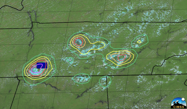
NOAA satellites have been monitoring a potent and complex spring weather pattern responsible for nearly a week-long stretch of severe weather, including two destructive tornado outbreaks across the central U.S. from May 15–16 and May 18–20, 2025.
Feature Story

NOAA contributes 90% of the weather information used by the defense and intelligence communities. Satellites offer a view unrivaled by terrestrial technology.
Satellite Snapshots

NOAA satellites have been monitoring several large wildfires in Minnesota.
Earth from Orbit

NOAA satellites have been closely monitoring the Jones Road Fire, which erupted on Tuesday, April 22, 2025, in a region of eastern New Jersey known as the Pine Barrens. Fueled by strong, gusty winds, low humidity, and dry undergrowth, the blaze has…