
NOAA plans to include a lightning mapper as part of the GeoXO system. The first GeoXO satellite will fly the GOES-R Series Geostationary Lightning Mapper (GLM). A future GeoXO satellite may include a new GeoXO Lightning Mapper (LMX) that potentially improves upon the resolution of the GLM and extends coverage to see Alaska, pending funding availability.
Both GLM and LMX are single-channel, near-infrared optical detectors used to detect, locate, and measure the intensity, duration, and extent of lightning flashes. Lightning mapping from geostationary orbit improves severe storm analysis and increases warning lead time for hazardous weather. The GLM also improves lightning hazard detection, hurricane intensity prediction, wildfire detection and response, precipitation estimation, and aviation hazard mitigation.
Geostationary lightning data is available where other sources are more limited, especially over oceans and in mountainous and rural areas. The data updates faster than local radar and also fills in radar coverage gaps.
Benefits of a Geostationary Lightning Mapper
Lightning mapping from geostationary orbit supports persistent severe weather observations of the Western Hemisphere and provides essential forecast information for public safety and efficient economic activity across multiple sectors. During ground radar outages a lightning mapper like GLM or LMX also provides crucial coverage acting as a substitute for any heavily damaged radar during disasters like hurricanes.
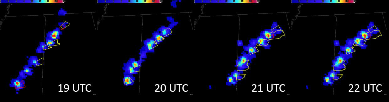
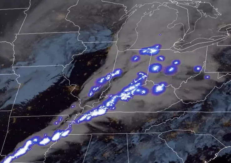
Warmer colors in the flash extent density indicate the most frequent GLM flashes, with the most strikes typically collocated with severe thunderstorm (yellow) and tornado (red) warning polygons. When used in conjunction with radar data, these lightning trends allow forecasters to make warning decisions earlier and more confidently. Credit: NOAA
Severe Weather Forecasting and Warning
Severe storms and associated hazards have cost the United States more than 228 billion dollars in the last 20 years. Rapid increases in total lightning activity often precede severe and tornadic thunderstorms. Characterizing lightning activity in storms allows forecasters to identify intensifying storms before they produce damaging winds, hail or tornadoes. Lightning mapping data allows forecasters to detect electrically active storms, determine the extent of the lightning threat, identify strengthening and weakening storms, monitor storm evolution, and supplement radar data where coverage is poor. Integrating satellite lightnimg data into the severe weather warning process also leads to fewer false alarms, especially during radar outages and in regions with poor radar coverage.
Lightning observations also contribute to satellite precipitation estimates, benefiting flash flood forecasting in significant portions of the western continental U.S., Hawaii, and U.S. territorial islands that lack adequate radar coverage.
Hurricane Analysis and Forecasting
Forecasters will use GLM/LMX data to assess hurricanes, particularly for forecasting intensity changes, monitoring convective patterns beneath the cloud tops, and helping establish location. Lightning data helps to diagnose hurricane structure and evolution and aid forecasts of intensity change including rapid intensification. Several studies noted a relationship between increased inner-core or rainband lightning activity and a change in the intensity of a hurricane. In some cases, lightning bursts preceded rapid intensification.
Wildfire Applications
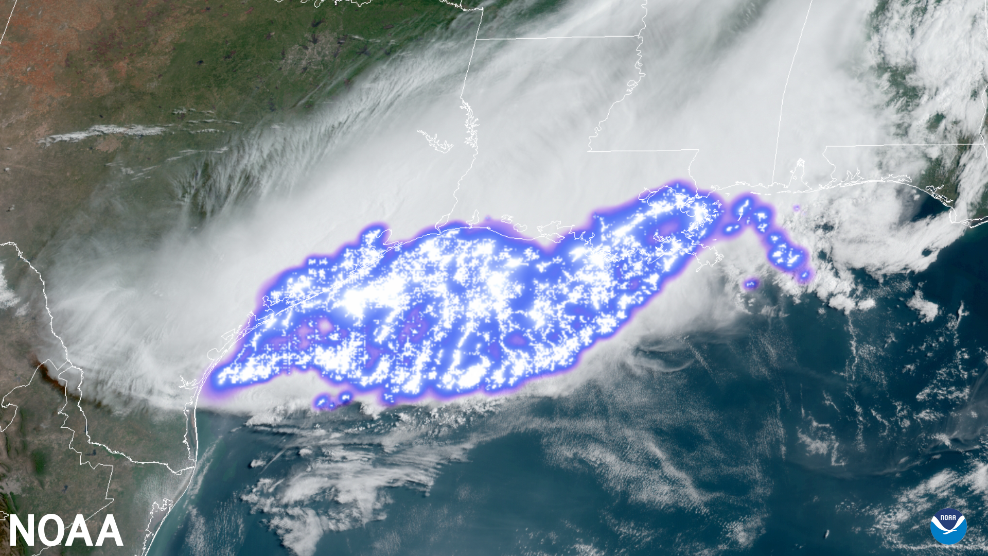
Lightning-initiated wildfires account for more than half of the acreage burned in the continental United States. Many lightning-ignited fires occur in less populated areas, resulting in delayed detection and suppression.
Early Detection of Lightning-Ignited Wildfires
Geostationary lightning mappers monitor vast areas to identify the sustained “continuing current” lightning flashes most likely to ignite fires. In continuing current strikes, rather than a lightning charge flowing in one or more separate return strokes, the charge flows continuously over a longer period through the lightning channel. This enables emergency personnel to find small and even smoldering fires before they grow, reducing forest and property loss, lowering firefighting costs, and improving air quality.
Improving Safety and Effectiveness of Wildfire Response
Mapping potential fire starts and identifying smaller fires before they grow benefits firefighting efforts and mitigates loss of life and property. Also, intense fires can produce large plumes of heat and smoke that can generate lightning and ignite additional fires. GLM/LMX will help characterize these pyrocumulonimbus clouds that threaten firefighters by spawning erratic winds and severe weather near wildfires.
Public Safety and Aviation Hazards
Lightning mapping applications enhance public safety across broad segments of society.
Public Safety
Lightning is a significant threat to life and property, and is particularly hazardous for those working outdoors and participating in recreational activities, and for the transportation industry. Geostationary lightning data provides awareness of local lightning conditions and promote better lightning safety decisions, leading to fewer lightning-related injuries and deaths.
In large, long-lived storm systems, lightning may travel hundreds of miles before striking the ground. GLM/LMX will show forecasters areas far from the main line of storms where the risk of lightning strikes to the ground presents a public safety hazard.
Benefits to the Aviation Industry
The airline industry benefits from using lightning mapping data to mitigate aviation hazards and reduce weather-related costs. GLM/LMX will support the safety and efficiency of both ramp operations and airplanes en route (and on approach). Lightning mapping can provide tremendous cost savings to the aviation industry through improved diagnosis and avoidance of thunderstorm hazards, especially over oceans. GLM/LMX will contribute to the reduction of aircraft lightning strikes by identifying electrified cloud regions that are not well-characterized by ground-based systems. This lightning data can also contribute to cost savings through reduced fuel burn and fewer delays and diversions.
Forensics Investigations
GLM/LMX will help authorities and insurance companies determine the existence of convection during investigations of fire cause as well as whether lightning caused a power outage or injury in remote areas. This data will also be used to prove the existence of convection that could be associated with high thunderstorm winds, hail, or tornadoes. GLM/LMX will provide information about the timing and intensity of lightning in the area
Environmental Hazards
GLM/LMX will also identify potentially catastrophic non-weather events such as very bright meteors entering Earth’s atmosphere and lightning accompanying explosive volcanic eruptions.
LMX Value Assessment Report
Learn more about the benefits of geostationary lightning mapping observations in NOAA’s Technical Report: Geostationary Lightning Mapper Value Assessment
Related Links
- GLM fact sheet
- GLM detection methods quick guide
- GLM operational applications quick guide
- National Weather Service Lightning Safety webpage
- National Severe Storms Laboratory – Lightning Basics
- Video Weather Briefly: Lightning
The information on this page is subject to change as the GeoXO program develops.